Showing posts with label travel. Show all posts

Monday, December 9, 2013

Top Ten Holiday Delicacies from Around the World

Ever wonder how people in other countries celebrate winter festivities, and what they eat? These international holiday delicacies show us a little bit about how others celebrate winter and religious festivals at the close of the year. Journey around the world and get a taste of ten traditional holiday foods unique and special to distinct countries.


Sorrel Recipe from Vegetarian Times
JamaicaSorrel
Sorrel is a traditional Christmas drink made from dried parts of the sorrel (a meadow plant), cinnamon, cloves, sugar, orange peel and rum, served over ice. The warm tropical weather of Jamaica means iced drinks are in order for the holidays, and incorporating native plants creates a recipe unique to the island.


Chili – Cola de Mono – Chilean Eggnog
This Chilean eggnog is a part of both Christmas and New Year’s Eve traditions. Usually homemade, the recipe varies but popular ingredients include milk, sugar, alcohol, coffee, cloves and vanilla beans.

United Kingdom - Christmas Pudding
United Kingdom map from mapsales.com
A traditional treat in England, Christmas Puddings are made from many dried fruits, spices, alcohol and held together by egg. The high content of alcohol allows the pudding to be aged for a month or even a year without spoiling, enhancing the flavor.

GreeceLoukoumades – Donuts
Loukoumades are pastries made of fried dough, soaked in sugary syrup or honey, and then covered with cinnamon and sometimes powered sugar. These pastries are often made as treats for Hanukkah in the Jewish tradition.

Mince Pies recipe from FoodHub
New Zealand – Christmas Mince Pies
Historically, ground beef with dried fruit and alcohol were baked into pie dough, though today mincemeat pies are usually made without meat at all. Strongly associated with Christmas, the three spices traditionally used in mince pies –cloves, nutmeg and cinnamon- are said to represent the three gifts given to the Christ child by the Magi.

Korea – Duk Gook – Rice Cake Soup
Korean Duk Gook, a soup filled with Korean rice cakes is eaten on the Winter Solstice or New Year’s Day. It is considered good luck to eat as many rice balls from the soup as years you have lived.

South AfricaMalvapoeding – Marshmallow Pudding
South Africa map from mapsales.com
Malvapoding, or marshmallow pudding, is smothered in a heavy cream and sugar-filled sauce, creating a spongy texture similar to marshmallows. The name ‘Malva’ came from Malvacea wine that Dutch colonists used to serve with the pudding in the 17th century.

Medianyky recipe at The Ryersonian
UkraineMedianyky – Honey Cookies

These honey cookies look like lace and are cut into stars, crescents or circles. A popular tradition is to hang them on low branches of the Christmas tree for children to eat.


HungaryGermanyAustria – krambambuli - Spicy Punch
This spicy punch is made with chamomile flowers, chopped fruit, candied orange peel, walnuts, sugar, rum, brandy and more. The specific recipe varies from family to family and country to country, but always a popular warm choice for wintertime festivities.

Philippines – Tsokolate – Hot Chocolate
Phillipines Map from mapsales.com
On Christmas day, families in the Philippines gather and drink tsokolate, a native chocolate drink made with egg yolks, milk and chocolate. Traditionally a batirol, a whisk with a spiky head, is used to make the hot chocolate.

Interested in Exploring the World on Wall Maps of your favorite countries and locations? Wall Maps make great gifts; use coupon code GIFT5642 at checkout to receive 15% off your order! Offer ends Tuesday, December 17th. 

Thursday, July 25, 2013

Master List of Map and Geography Jokes!

mapsales.com has searched the web far and wide for the best map jokes. We’ve included funny geography jokes and travel jokes as well. Whether you are taking a family trip or teaching students about geography, map jokes can break the ice and get children and adults conversing about places around the world, geography and maps!

Enjoy these funny map jokes!

Q. What do John Wayne and a map key have in common?
A. Both are legends.

Q. Why do paper maps never win at poker?
A. Because they always fold.

Q. What did the mapmaker send his sweetheart on Valentine’s Day?
A. A dozen compass roses.

Q: What always sits in the corner but can move all round the world?
A: A stamp!

Q: Why is it easy to get into Florida?
A: Because there are so many keys.

Q: What is round at each end and high in the middle?
A: Ohio.


Q: What did the sea say to the shore?
A: Nothing, it just waved!

Q: What do fish and maps have in common?
A: They both have scales!

Q: What kind of maps do spiders make?
A: Web-based maps!

Q. What is smarter, longitude or latitude?
A. Longitude, because it has 360 degrees

Q. Why does west longitude need to be cheered up?
A. Because it is always negative.

Q. What map element plays in the band?
A. The symbols (cymbals).

Q: What’s a map favorite type of syrup?
A: Map-le syrup!

Q: Where do fish keep their money?
A: In riverbanks.

Q: Where is it always 90 degrees, but never hot?
A: The North and South Poles.

Q: What do you get if you cross a farm animal with a map maker?
A: A cow-tographer!


Q: What rock group has four men that don't sing?
A: Mount Rushmore!

Q: What would you get if you crossed a river and a desert?
A: Wet and thirsty.

Q: Who is the coldest relative on earth?
A: Aunt Arctica.

Q: What's the coldest city in Germany?
A: Brrr lin (Berlin).

Q: Where can you find lots of shoes?
A: In the foothills!

If you liked these map jokes, share them with your friends!

Friday, July 12, 2013

Tips for Hiking in the Rain: Synthetic Maps Won’t Get Wet!

Explore the Outdoors with Synthetic Topographic Maps
Backpackers, get ready for your summer adventures with detailed topographic maps from mapsales.com. All you need is a map and a compass to start exploring!

Topographic Quad Map of Mount Saint Helen

1. Choose Synthetic Maps
However, weather is unpredictable, and in the summer, sudden rains can make navigating (especially with electronic devices!) difficult. There are a few options for adventurers:
  • Put your maps in plastic sleeves (difficult to remove and open to new section without getting the paper wet)
  • Get Laminated Maps (difficult to fold)
  • Get Synthetic Maps!
Synthetic Paper Maps are water-resistant and fold-able, perfect for hiking in any weather!

2. Get Detailed Topographic Maps
  • Every County Across the USA
  • Contour Lines with Elevation and Shape of Terrain
  • Towns, Water Ways and Other Landmarks
  • Quad Maps show Even Greater Detail


3. Have a Back-up Plan
While we don’t like having to rely on GPS (sometimes they spoil the fun of exploring!) it’s good to have a back-up plan. This may take some extra planning, including: overestimating the time it will take you to navigate, bringing extra food and water, having a meeting place and a plan for bad weather! Plan alternate routes in case of flooding rivers or low visibility of geographic features.

Your back-up plan should also include having a back-up map or GPS system on hand!


So, this summer, put your GPS away (as a backup) and explore the outdoors with the old-fashioned compass and map, even in the rain!

Thursday, June 27, 2013

DIY Map Crafts: Beautiful Map Artwork and Do-it-Yourself Map Crafts

Here are some of the best map crafts we've seen around the web lately. If you follow us on pinterest, you can find even more map do it yourself crafts and art.

There’s no limit to what you can do with maps. Already graphically engaging and informative, maps lend themselves well to incorporation or inspiration in all kinds of art. Artists render their own maps using an outline as a starting point, or cut, paste and overlay maps for visual interest. We love what these artists have done with maps!


DIY Quilled Map Craft Art
Like this beautiful quilled map by Amber Rousse. You can tell she spent many hours perfecting each quill. The land even has mountains! Now that’s a three dimensional map!

DIY Clock Map Craft
We love this DIY map clock, it’s beautiful and inexpensive! The materials? Clock workings, a round tin plate and a map. You could do this with any map, or get a custom map printed just for you!

DIY Map Wallpaper Craft
Create a wall full of maps! Your own unique map wallpaper of the places you been, and/or where you dream to go one day! We love this example of DIY map wallpaper. You can take any maps, old, new, vintage, antique and artistically design your own world.

DIY Map Embroidery Hoop Craft
Simple and elegant, these vintage maps are craftily displayed in wooden embroidery hoops. Similarly, you could use maps of any location and any style to achieve this look. Reminds me of maps with wooden rails because they have this vintage feel to them!


DIY Wedding Gift Map Location
A beautiful wedding gift. This map could represent the location and date of the wedding, where they met, or the location of the proposal. If you’re not a designer, you can get a custom map made with the location marked and the names printed in any design, of any location!

I hope you felt inspired and not intimidated by all this beautiful DIY map artwork! And, if you don’t have crazy amounts of time or the will to stay up all night and craft with maps, you can always go to mapsales.com and shop for beautiful paper, laminated, framed and magnetic maps of all sizes (even large enough to cover an entire wall!). Or call and have a map custom designed just for you!

If you read all the way down to here, you probably liked this article...so share it with your friends!

Thursday, June 20, 2013

Texas State Maps: Best Wall Maps of Texas

Texas State Maps with roads, cities, counties, outlines, colors and more!

mapsales.com has compiled a list of our favorite Texas State Maps. Whether you're planning a trip, marking business locations or decorating your home, if Texas holds a place in your heart, the beautiful state terrain belongs on your walls too!


Texas Satellite Physical Wall Map

Texas Satellite Wall Map 

This Texas State Map shows what TX looks like from space! The striking map combines images obtained from NASA's Landsat satellites with 3-D shading to provide an image of Texas unlike anything you've ever seen. High resolution satellite imagery and clear visibility of individual crop fields  rivers, urban areas, and even large airports make this Texas Wall Map stand out in vivid detail. Order the largest size which will fit your wall to enhance the visibility of detail. Enjoy the natural beauty of the state of Texas with a Texas Satellite Wall Map!


Texas County Outline Map

Texas Map with Counties Outline
This Texas State Map features county names and boundaries with major cities. The clear county borders and lack of clutter make this state map great for businesses! Use dry erase markers to write on this laminated map. Color in your county, or your business's market areas on this Texas County Outline Map.


Texas Zip Code Map with Cities

Texas Zip Code & Cities Wall Map
This Texas State Map features a beautiful red colorcasting of all major highways and roads across Texas. Find all major cities on this Texas Map with cities. Insets feature road maps of 17 metro areas. With 5 digit zip codes and a zip code grid locator, the Texas Zip Code Map shows the details you need for finding locations and planning road trips!


If you read this far, you probably liked this post, so please share!

Thursday, June 13, 2013

Napa Valley Winery Map: Plan a Visit to the California Country


Explore Napa Valley Wine Country on this beautiful wall map! World over, Napa Valley is popular for its wines, wineries and vineyards. Located just north of San Francisco in northern California, Napa Valley boosts beautiful sunny weather and lush fields.


Planning a trip to Napa Valley this summer? Use this beautifully designed Napa Valley Winery Map to plan your trip!

Find the locations of Napa Valley wineries & vineyards. The vineyard location legend tells you accessibility features, hours, contact info and cross-referenced locations. This Napa Valley Winery Map is perfect for planning your vacation to visit the Napa Valley County in California.

Napa Valley Winery Map
There are over 150 Vineyards & Wineries on the Napa Valley Winery Map, including these popular locations:

  • Joseph Phelps Vineyard
  • Bravante Vineyards
  • Domaine Carneros
  • Artesa Vineyards & Winery
  • Silverado Vineyards


  • Vineyards
  • Cities
  • Interstates/Highways
  • Secondary Roads
  • Physical Terrain
  • Latitude/Longitude lines
  • Points of Interest
  • Legend
  • Index
  • Elevation Info

Zoom in on the Napa Valley Winery Map to see the stunning detail. Great for planning, this wall map also makes a wonderful keepsake that will display the memories of your trip for years.

Thursday, June 6, 2013

Best Yosemite National Park Map

What's the best Yosemite National Park Map to plan a trip with?


Yosemite has some killer maps, photos and stories all across the web...here's a couple of map options so you can plan your trip with the best Yosemite National Park Map!

View this Yosemite National Park Map

What does this Yosemite National Park Map by Geonova feature?


  • All campground locations
  • Points of Interest including Yosemite Falls, Badger Pass, Wapama Falls and more!
  • Mountains with peak height
  • Information Center locations
  • Locations of lakes and rivers
  • Detailed roads and trails


Zoom in on Yosemite Park Map


How does it compare to the Yosemite National Park Map by National Geographic?

  • Detailed topography
  • Picnic as well as campground locations
  • Hiking train mile markers - know how long trails are!
The result? While we love the Yosemite National Park Map by Geonova for the vivid color, it's better as a keepsake and  decorative map. The Yosemite National Park Map by National Geographic is the best map for planning, traveling and camping in Yosemite Park.


What are some interesting facts about Yosemite National Park?

  • Giant Sequioas are the largest living things on the planet! They grow in Yosemite National Park
  • The vast majority of the park's 1,200 square miles is uninhabited by humans and often only 7 square miles are traversed by visitors!
  • Yosemite contains 20% of California's 7,000 known plant species.
  • Yosemite Falls is the highest waterfall in North America and third highest in the world, standing out at 2425 feet.

Thursday, May 30, 2013

Places on Earth that Look like Mars

Landscapes of Mars? Some photoshop trick? No, these weird places are real...and a lot closer than they look. On earth, in fact! Take a look at these places on earth that look like Mars and see where they are really located on wall maps.


Rio Tinto, Spain 

The tinted waters of Rio Tinto in Spain give an eerie martian glow. Acidic with a pH of 2 and a deep redish hue, Rio Tinto looks both alien and beautiful. The extreme conditions in the river are analogous to other locations in the solar system thought to contain liquid water, such as subterranean Mars. The Rio Tinto is located in southwestern Spainoriginates in the Sierra Morena mountains of Andalusia and flows to the Gulf of Cádiz at Huelva.

Lake Natron, Tanzania


The red coloration in lake Natron occurs as salt-loving microorganisms are colored red and use photosynthesize with red pigmented accessories. See it on a Wall Map of Tanzania!


Yellowstone National Park, USA

The weird colors of Yellowstone National Park are caused by the extremophiles living in very hot water. The landscape of Yellowstone National Park is varied and unusual due to the high concentration of geothermal features including geysers, volcanic activity and earthquakes.


And, finally, see a physical wall map of Mars, with all the physical features we have mapped despite the 50-100 million kilometers of distance between Earth and Mars.


Thursday, May 9, 2013

The Best Wall Map Ideas for the Home

Ever see those beautiful maps on Pinterest and wondered where to buy them and how to decorate with maps? We've scouted out some beautiful wall map decor ideas for the home, and how you can get the same maps!

Bold USA Wall Map for the Bedroom


This USA Wall Map looks great over a master or guest bed. The blue, red and yellow primary color scheme is consistent throughout the room. Following the color scheme in a map is an easy way to make design choices for a room!

We found where to buy this USA Executive Wall Map below!
USA Executive Wall Map
Get this USA Executive Wall Map!


A Wall Map Across the Entire Wall


This room is one of our favorites, and it's popular on pinterest as well! The white and brown color scheme allows the blue of the beautiful oceans to really pop.

I just imagine having an intimate dinner here with friends just back from vacation. We'd be able to see exactly where they'd gone on this map! And, we found this same Political Wall Map for sale online. You can get it as large as 9x12 feet!
Political World Wall Map


Unusual Thematic Wall Maps for Modern Decor


This wall map hangs over the bed with wooden railings. Just like an old vintage classroom map!

The stark white combined with bright pops of color add life to the room. The hanging lights draw the focus further to the focal piece of the room, the World Climate Wall Map! This unusual wall map features bright bold colors for a modern design.
World Climate Wall Map
World Climate Wall Map Available on Spring Rollers
If you read this article to the end, you probably liked it, please share it with your friends using the buttons below!

Friday, March 1, 2013

Hawaii Wall Map: View the Happiest State in the USA

The Hawaiians are the happiest people in the nation according to a new Gallup-Healthways poll. mapsales.com takes a look at the survey and the best Wall Maps of Hawaii.

It’s no surprise: Hawaii is a prime vacation location and Hawaii Wall Maps are popular travel keepsakes, reminding visitors of the lush greenery, beautiful beaches and surfing. Although we usually imagine only travelers having great experiences in Hawaii, apparently the residents make this the happiest state in the USA. At the bottom of the poll, West Virginia represented the lowest overall well-being among US States.

Our Favorite Hawaii Wall Map
Learn more about the happiest state in the USA with this Hawaii Wall Map. The poll used telephone interviews conducted all last year.  A total of 353,564 random American adults were polled from all across the USA, and even the District of Columbia. They measured six elements of happiness: life evaluation, emotional health, work environment, physical health, healthy behavior and basic access.

Hawaiian residents reported the highest score on life evaluation, which included self-evaluation about your present life situation and anticipated one in five years. They also scored high for emotional health: they were more likely to have smiled or laughed a lot the previous day, and the least likely to have daily worry or stress.  Although they didn't score the highest in each category, Hawaiian happiness overall makes Hawaii the happiest state in the USA.

The Happiest State: Hawaii Wall Map
Another great wall map of Hawaii, FindIt Hawaii shows all roads and topographical features, perfect for the traveler. Explore, plan and travel across the major islands: Hawaii, Maui, Oahu and Kauai with this Hawaii Wall Map. Where would you go first? Or would you prefer to live all year in Hawaii?

Tuesday, February 12, 2013

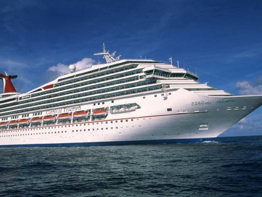
Planning a Cruise? Carnival Cruise Ship Stranded

A fire on Sunday debilitated a Carnival Cruise Ship in the Gulf of Mexico. More than 4,200 people are on board without power or plumbing. Two tugboats will be required to tug the larger-than-Titanic Carnival Triumph. The ship had drifted north and is expected to arrive in Mobile, Alabama on Thursday. Until then, other ships have brought much-needed supplies.
Zoom in to find Mobile, Alabama on this Countries of the Caribean Wall Map

Because of plumbing issues, many passengers are sleeping in the hallways or on the deck. With limited access to bathrooms, food and hot coffee, passengers are forced to simply wait it out until they get tugged to port.

Cruises are a popular type of vacation. For the ticket price, a passenger gets pampered while visiting different countries or islands. While passengers may brave getting off the ship to explore different ports for a period of time, they are able to return to the ship in time to enjoy a lobster dinner and hot tub soak. For those unwilling to trust flights, foreign hotels or food, it is a way to safely explore some of the world.

Take a cruise or backpack in the wild?

However, many people commenting on the yahoo.com top stories report who have plans to travel on a Carnival cruise later this year are debating or flat-out stating that they will cancel their cruise. We may see a decrease in cruise ship vacation popularity. Perhaps we will see an increase in other types of travel vacations, traveling by flight or car with visitors venturing farther into foreign countries, beyond the tourist-geared ports. When planning your vacation, be sure to ask around, explore some maps, and research your location first!

This Antique Countries of the Caribbean Wall Map shows the Gulf of Mexico with shipping lines. Zoom in to find where the Carnival Triumph will be towed: Mobile, Alabama.

Which would you rather do: take a cruise, or backpack in the wild?

Tuesday, January 29, 2013

Riding the Largest Waves: from California to Portugal

In the wake of Garrett McNamara possibly breaking his own world record for the largest wave surfed, mapsales.com takes a look at geographical features that cause large waves, and where to find them!


How do Waves get so Large?

Zoom in on this Portugal Wall Map to find where McNamara set his world record in 2001: Narare, Portugal.

“There is an underwater canyon 1,000 feet deep that runs from the ocean right up to the cliffs. It’s like a funnel. At its ocean end its three miles wide but narrows as it gets closer to the store and when there is a big swell it acts like an amplifier,” McNamara explains. The ocean floor is far from flat; geographical features play a large role in determining how waves crash and how large they can get. Zoom in on this World Physical Ocean Floor Map to see the variations of our oceans!


His newest record, possibly over 100 feet, took place yesterday also in Praia do Norte, Nazare, Portugal. The previous world record by mark Parsons occurred in Cortes Bank, California. California is well-known for their surfing competitions, including the Mavericks Invitational big-wave competition, which restarted this year after a series of waves crashed spectators in 2010. Even wave-watching can be dangerous when the waves range from 20 to 90 feet!

While previous world records have been documented all over the world, Portugal may increase in popularity for thrill-seeking surfers looking for the largest waves. Take a look at this Portugal Wall Map to plan your next trip!


Previous World Records for Tallest Wave Surfed
1. Garrett McNamara, 78 ft wave
Nazaré, Portugal in November 2011
2. Mark Parsons, 77ft wave
Cortes Bank, California in January 2008
3. Pete Cabrinha, 70ft wave
Jaws Beach, Maui in January 2004
4. Brag Gerlach, 68 ft wave
Todos Santos, Mexico in December 2005

Shop Wall Maps!

Monday, January 7, 2013

Winter Ski Guide

The winter season doesn’t end with Christmas and New Years. You’ve still got a few months to grab your skis, head up the mountains, and find some great snow-covered trails. mapsales.com gives you some great winter skiing destinations.


Vail, Colorado
Vail is a unique skiing environment. It is home to the country’s largest ski school (with over 1,000 instructors), and it offers more groomed terrain than any other resort. Alpine skiing is popular in Vail, as is its cross–country skiing. Enjoy a beautiful view of the Southern Rockies on one of the many ski lifts before you head down the mountainside.


Big Sky, Montana
Big Sky welcomed its first skiers in the 1970s. Although it is a newer resort, its reputation has quickly spread and it is now one of the most popular winter destinations. At Big Sky, you have access to 5,512 skiable acres with 25 lifts and over 220 runs.


Cortina, Italy
One of the world’s oldest ski resorts sits atop the Dolomite Mountains, about 3 hours outside of Venice, Italy. For 2 centuries, skiers have been flocking to Cortina d’Ampezzo to enjoy unrivaled slopes, local pubs, and traditional homemade Italian dinners.


Mt. Tremblant, Canada
Mt. Tremblant is distinguished as Canada’s first ski resort, and the second in North America. Nestled in the mountains just outside Quebec’s capital city, the village surrounding Mt. Tremblant is rich in French cuisine and heritage. In the next decade, the resort will expand its skiable acres from 625 to 1,000, increasing the number of skiers from 12,000 a day to approximately 20,000.


Want to learn more about winter locations around the world? Try a map! mapsales.com carries over 200,000 wall maps…delivered as fast as next day!


View more maps of the world!