Showing posts with label National Park maps. Show all posts

Thursday, June 6, 2013

Best Yosemite National Park Map

What's the best Yosemite National Park Map to plan a trip with?


Yosemite has some killer maps, photos and stories all across the web...here's a couple of map options so you can plan your trip with the best Yosemite National Park Map!

View this Yosemite National Park Map

What does this Yosemite National Park Map by Geonova feature?


  • All campground locations
  • Points of Interest including Yosemite Falls, Badger Pass, Wapama Falls and more!
  • Mountains with peak height
  • Information Center locations
  • Locations of lakes and rivers
  • Detailed roads and trails


Zoom in on Yosemite Park Map


How does it compare to the Yosemite National Park Map by National Geographic?

  • Detailed topography
  • Picnic as well as campground locations
  • Hiking train mile markers - know how long trails are!
The result? While we love the Yosemite National Park Map by Geonova for the vivid color, it's better as a keepsake and  decorative map. The Yosemite National Park Map by National Geographic is the best map for planning, traveling and camping in Yosemite Park.


What are some interesting facts about Yosemite National Park?

  • Giant Sequioas are the largest living things on the planet! They grow in Yosemite National Park
  • The vast majority of the park's 1,200 square miles is uninhabited by humans and often only 7 square miles are traversed by visitors!
  • Yosemite contains 20% of California's 7,000 known plant species.
  • Yosemite Falls is the highest waterfall in North America and third highest in the world, standing out at 2425 feet.

Thursday, February 7, 2013

Digital Maps Versus Paper Maps


There’s a lot of media buzz recently about not only how amazing digital maps are, but also their failings. Do we rely too much on digital maps? mapsales.com takes a look at how technology has improved the usability of paper maps as well.

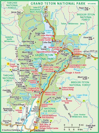
If you’re worried about bad weather affecting your paper maps while hiking or skiing, invest in synthetic paper maps. For example, while testing out Google’s Ski Resort coverage at Jackson Hole Mountain Resort, you can also take this Grand Teton National Park Map to check out the trails, museums, and other points of interest, without worrying about wear and tear or water stains.


Today we might still recognize the motif of a man refusing to ask for directions, poring over a large paper, fold-out map. That motif may well become obsolete. Our digital devices give a (mostly) precise description of our location and (mostly) correct directions to wherever we’d like to go, even speaking the directions so we don’t have to consult the on-screen map.

However, what happens when technology fails? Apple maps are the most well-known example of this failure, leaving a group in Australian stranded in a national park 40 miles away from their destination. Smaller mistakes do occur, as well as the very real possibility of running out of battery power.

The fact that, as Christine Ortiz notes in Why Digital Maps Aren’t Ready to Replace Paper, military personnel still prefer to consult paper maps, says a lot about the benefit of keeping a paper map backup in your car or backpack. This may be especially handy in areas where satellite coverage is sparse, with maps of the rural areas or National Park Wall Maps.

Check out more wall maps at mapsales.com.