Showing posts with label Bizarre. Show all posts

Thursday, July 25, 2013

Master List of Map and Geography Jokes!

mapsales.com has searched the web far and wide for the best map jokes. We’ve included funny geography jokes and travel jokes as well. Whether you are taking a family trip or teaching students about geography, map jokes can break the ice and get children and adults conversing about places around the world, geography and maps!

Enjoy these funny map jokes!

Q. What do John Wayne and a map key have in common?
A. Both are legends.

Q. Why do paper maps never win at poker?
A. Because they always fold.

Q. What did the mapmaker send his sweetheart on Valentine’s Day?
A. A dozen compass roses.

Q: What always sits in the corner but can move all round the world?
A: A stamp!

Q: Why is it easy to get into Florida?
A: Because there are so many keys.

Q: What is round at each end and high in the middle?
A: Ohio.


Q: What did the sea say to the shore?
A: Nothing, it just waved!

Q: What do fish and maps have in common?
A: They both have scales!

Q: What kind of maps do spiders make?
A: Web-based maps!

Q. What is smarter, longitude or latitude?
A. Longitude, because it has 360 degrees

Q. Why does west longitude need to be cheered up?
A. Because it is always negative.

Q. What map element plays in the band?
A. The symbols (cymbals).

Q: What’s a map favorite type of syrup?
A: Map-le syrup!

Q: Where do fish keep their money?
A: In riverbanks.

Q: Where is it always 90 degrees, but never hot?
A: The North and South Poles.

Q: What do you get if you cross a farm animal with a map maker?
A: A cow-tographer!


Q: What rock group has four men that don't sing?
A: Mount Rushmore!

Q: What would you get if you crossed a river and a desert?
A: Wet and thirsty.

Q: Who is the coldest relative on earth?
A: Aunt Arctica.

Q: What's the coldest city in Germany?
A: Brrr lin (Berlin).

Q: Where can you find lots of shoes?
A: In the foothills!

If you liked these map jokes, share them with your friends!

Thursday, May 30, 2013

Places on Earth that Look like Mars

Landscapes of Mars? Some photoshop trick? No, these weird places are real...and a lot closer than they look. On earth, in fact! Take a look at these places on earth that look like Mars and see where they are really located on wall maps.


Rio Tinto, Spain 

The tinted waters of Rio Tinto in Spain give an eerie martian glow. Acidic with a pH of 2 and a deep redish hue, Rio Tinto looks both alien and beautiful. The extreme conditions in the river are analogous to other locations in the solar system thought to contain liquid water, such as subterranean Mars. The Rio Tinto is located in southwestern Spainoriginates in the Sierra Morena mountains of Andalusia and flows to the Gulf of Cádiz at Huelva.

Lake Natron, Tanzania


The red coloration in lake Natron occurs as salt-loving microorganisms are colored red and use photosynthesize with red pigmented accessories. See it on a Wall Map of Tanzania!


Yellowstone National Park, USA

The weird colors of Yellowstone National Park are caused by the extremophiles living in very hot water. The landscape of Yellowstone National Park is varied and unusual due to the high concentration of geothermal features including geysers, volcanic activity and earthquakes.


And, finally, see a physical wall map of Mars, with all the physical features we have mapped despite the 50-100 million kilometers of distance between Earth and Mars.


Friday, April 26, 2013

The Oddest, Most Bizarre Maps


"Mapping our world" can mean a multitude of things. From our first map of a schoolyard or home, to maps of our favorite places to dine, maps of places we've traveled, maps play different roles in our lives, from the classroom, in our minds, in vacations and to artwork. Take a look at a few of these strangely bizarre maps. They'd make great decor and conversation starters at least!

Click on the pictures to zoom in on any wall map; take a detailed look at the world from an unusual perspective!

Titanic Navigation Chart Wall Map
Chart the the path the largest ship of it's time took across the Atlantic Ocean! Marine Charts are usually coveted by a very specific set of people, but the legacy and myth surrounding the story of the Titanic's maiden and final voyage makes this an usually popular map!

Titanic Navigation Chart Wall Map


Muir Glacier Alaska Wall Map
Artistic and minimalist, this map of Alaska shows the Muir Glacier in Glacier Bay National Park. The challenge of mapping a glacier make this bizarre map a work of art.

Muir Glacier Map in Alaska


Upside Down World Wall Map
View the world from a different perspective with this Upside Down World map. After all, there is no "UP" in outer space! This bizarre map shows us how the image of the world "right-side up" is imprinted and ingrained into our minds.

Upside Down Wall Map


Mars Physical Wall Map
We've barely started exploring space but we can already map out our sister planet Mars. This odd map shows more than it appears to at first glance, just zoom in to see!

Wall Map of the Planet Mars


Thursday, February 14, 2013

Satellites Show Disturbing Images of North Korea


Seismic activity was detected after the blast of North Korea’s latest nuclear test. The U.S. Geological survey was able to pinpoint the location of the blast. Google maps show Nuclear Test Road, leading up a mountain and Nuclear Test Facility. The location of the blast is not far from Nuclear test Road.


As a very closed-off country, not a lot is known about North Korea from first-hand accounts. In this case, we only have satellite data about the country's recent activity. And that geographical information can reveal more than the country probably wants revealed. 

Other disturbing images of North Korea include satellite images of gulags, brutal concentration camps. North Korea has denied the existence of these camps, but the satellite images serve as compelling evidence, evidence that could prompt action to end these atrocities. 

Until then, we can only continue to improve our maps and understanding of the world. "We know this map is not perfect," Google senior product manager Jayanth Mysore said in a statement posted online, referring to the project of creating an accurate map of North Korea. "One of the exciting things about maps is that the world is a constantly changing place."

Physical Map of North Korea
View more wall maps!

Tuesday, January 29, 2013

Riding the Largest Waves: from California to Portugal

In the wake of Garrett McNamara possibly breaking his own world record for the largest wave surfed, mapsales.com takes a look at geographical features that cause large waves, and where to find them!


How do Waves get so Large?

Zoom in on this Portugal Wall Map to find where McNamara set his world record in 2001: Narare, Portugal.

“There is an underwater canyon 1,000 feet deep that runs from the ocean right up to the cliffs. It’s like a funnel. At its ocean end its three miles wide but narrows as it gets closer to the store and when there is a big swell it acts like an amplifier,” McNamara explains. The ocean floor is far from flat; geographical features play a large role in determining how waves crash and how large they can get. Zoom in on this World Physical Ocean Floor Map to see the variations of our oceans!


His newest record, possibly over 100 feet, took place yesterday also in Praia do Norte, Nazare, Portugal. The previous world record by mark Parsons occurred in Cortes Bank, California. California is well-known for their surfing competitions, including the Mavericks Invitational big-wave competition, which restarted this year after a series of waves crashed spectators in 2010. Even wave-watching can be dangerous when the waves range from 20 to 90 feet!

While previous world records have been documented all over the world, Portugal may increase in popularity for thrill-seeking surfers looking for the largest waves. Take a look at this Portugal Wall Map to plan your next trip!


Previous World Records for Tallest Wave Surfed
1. Garrett McNamara, 78 ft wave
Nazaré, Portugal in November 2011
2. Mark Parsons, 77ft wave
Cortes Bank, California in January 2008
3. Pete Cabrinha, 70ft wave
Jaws Beach, Maui in January 2004
4. Brag Gerlach, 68 ft wave
Todos Santos, Mexico in December 2005

Shop Wall Maps!

Wednesday, January 23, 2013

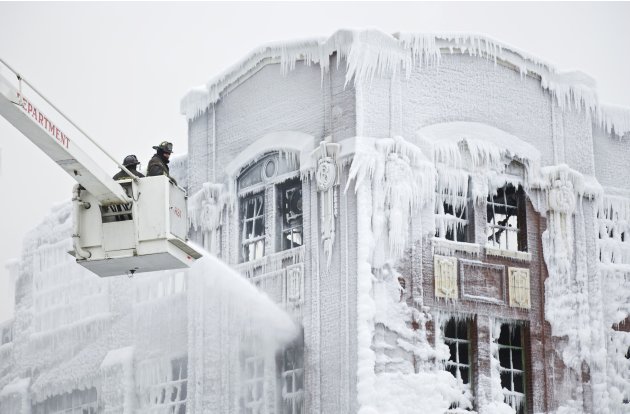
Bizarre Fire at Chicago Warehouse in Icy Weather

Last night, an abandoned Bridgeport warehouse caught fire, starting the largest Chicago fire in seven years. mapsales.com takes a look at the bizarre photos of the massive fire in icy temperatures.


The blaze was spotted shortly after 9 p.m. Tuesday evening. The fire department called extra alarms as the fire spread quickly through the warehouse and the roof collapsed. The bitter cold weather worked against them as over 200 firefighters contended with the massive fire as well as heavy ice on fire hydrants, hoses and ladders.


"Everything is wood inside these buildings, beautiful façades on the outside. They've been up for a long time. When they start burning like this, they start coming down," Chicago Fire Cmsr. Jose Santiago said.


Working against the frigid temperatures and building ice, the fire was finally brought under control around 12:30 a.m. Firefighters were still spraying down hot spots early this morning.


Chicago is remembered for the historic fire of 1871, one of the largest US disasters of the 19th century. A disaster which led to the rebuilding of Chicago and it’s emergence as one of the most populous and economically important American cities. See this transformation depicted in a 1916 Chicago Antique Wall Map, which shows a populous and thriving city forty years after the fire.

Perhaps the Bridgeport fire will allow rebuilding of the abandoned warehouse into something new and inspiring.