Showing posts with label sports. Show all posts

Friday, July 12, 2013

Tips for Hiking in the Rain: Synthetic Maps Won’t Get Wet!

Explore the Outdoors with Synthetic Topographic Maps
Backpackers, get ready for your summer adventures with detailed topographic maps from mapsales.com. All you need is a map and a compass to start exploring!

Topographic Quad Map of Mount Saint Helen

1. Choose Synthetic Maps
However, weather is unpredictable, and in the summer, sudden rains can make navigating (especially with electronic devices!) difficult. There are a few options for adventurers:
  • Put your maps in plastic sleeves (difficult to remove and open to new section without getting the paper wet)
  • Get Laminated Maps (difficult to fold)
  • Get Synthetic Maps!
Synthetic Paper Maps are water-resistant and fold-able, perfect for hiking in any weather!

2. Get Detailed Topographic Maps
  • Every County Across the USA
  • Contour Lines with Elevation and Shape of Terrain
  • Towns, Water Ways and Other Landmarks
  • Quad Maps show Even Greater Detail


3. Have a Back-up Plan
While we don’t like having to rely on GPS (sometimes they spoil the fun of exploring!) it’s good to have a back-up plan. This may take some extra planning, including: overestimating the time it will take you to navigate, bringing extra food and water, having a meeting place and a plan for bad weather! Plan alternate routes in case of flooding rivers or low visibility of geographic features.

Your back-up plan should also include having a back-up map or GPS system on hand!


So, this summer, put your GPS away (as a backup) and explore the outdoors with the old-fashioned compass and map, even in the rain!

Thursday, June 6, 2013

Best Yosemite National Park Map

What's the best Yosemite National Park Map to plan a trip with?


Yosemite has some killer maps, photos and stories all across the web...here's a couple of map options so you can plan your trip with the best Yosemite National Park Map!

View this Yosemite National Park Map

What does this Yosemite National Park Map by Geonova feature?


  • All campground locations
  • Points of Interest including Yosemite Falls, Badger Pass, Wapama Falls and more!
  • Mountains with peak height
  • Information Center locations
  • Locations of lakes and rivers
  • Detailed roads and trails


Zoom in on Yosemite Park Map


How does it compare to the Yosemite National Park Map by National Geographic?

  • Detailed topography
  • Picnic as well as campground locations
  • Hiking train mile markers - know how long trails are!
The result? While we love the Yosemite National Park Map by Geonova for the vivid color, it's better as a keepsake and  decorative map. The Yosemite National Park Map by National Geographic is the best map for planning, traveling and camping in Yosemite Park.


What are some interesting facts about Yosemite National Park?

  • Giant Sequioas are the largest living things on the planet! They grow in Yosemite National Park
  • The vast majority of the park's 1,200 square miles is uninhabited by humans and often only 7 square miles are traversed by visitors!
  • Yosemite contains 20% of California's 7,000 known plant species.
  • Yosemite Falls is the highest waterfall in North America and third highest in the world, standing out at 2425 feet.

Friday, May 17, 2013

Where Are NASCAR Race Tracks Located?


Brand New Map Shows Where NASCAR Race Tracks are Located


racetrack mapEver wonder where all the racetracks across the USA are located? Visualize your favorite and new racetracks with the new Racetracks of the United States Wall Map from publisher MarketMAPS. 

This racetrack map features 29 major racetrack locations across the USA and everything you need to keep track of your favorite races!


Answer these questions with the Racetracks Wall Map!


  • What's the longest race track?
  • Which auto race track has the weirdest shape?
  • Where's the closest superspeedway to your location?
  • What's the schedule for the 2013 NASCAR races?
racetracks map

Imagine planning a cross country road trip to visit all 29 major racetracks! 

We love the bold, bright colors on this map and the starting flag symbols representing cities. The larger flags represent higher-population cities.

Explore the Racetracks Wall Map in greater detail at mapsales.com!

If you read all the way to here, you probably liked this article, please share it!

Friday, April 5, 2013

New Baseball Map - Track Your Favorite Teams this Season

Baseball season has begun! Track your favorite teams this season with mapsales.com’s comprehensive Baseball Map. This wall map compliments collections of baseball memorabilia, brings a favorite sport to offices in a professional display and encourages children’s interest in Little League. The new baseball map from publisher MarketMAPS shows the city stadium locations of 303 teams from 26 Major, Minor and Independent Leagues across the US and Canada.

baseball map


Explore Favorite Teams and Discover New Favorites
Marvel at the sheer amount of teams and stadiums across the US and Canada. Find your favorite team on the wall map and learn about lesser known teams, spring training leagues and baseball popularity in any area. Track their travel as favorite teams play at different stadiums throughout the season. This comprehensive wall map includes team classes, baseball symbols for league types, city sizes, state boundaries, and major highways. 24 smaller maps showcase each league and the locations of their teams’ stadiums.

baseball map

Decorate with A Baseball Wall Map
This baseball map comes in a range of sizes, starting at 3x3 feet, perfect for any wall. The wall map’s color scheme embraces the green of the field balanced with sophisticated warm tones. mapsales.com recommends an executive frame for this wall map for professional and decorative display!

Monday, January 21, 2013

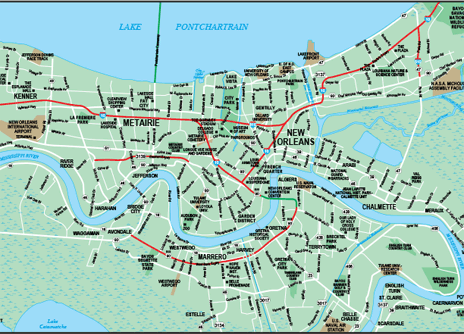
New Orleans, 2013: a Map to the Super Bowl

Last night, two football games in two separate cities determined which NFL teams would be facing off in Super Bowl XLVII. mapsales.com looks at what’s in store, and what’s at stake in this year’s Super Bowl.


Take a look at a New Orleans wall map and locate highways 10 and 90. Where they meet, you’ll find the Mercedes-Benz Superdome, the site of this year’s Super Bowl. After an exciting football Sunday, the stage is set for the San Francisco 49ers to take on the Baltimore Ravens in Super Bowl XLVII, which takes place February 3 (less than 2 weeks from today!)


Yesterday, we saw the 49ers beat the Atlanta Falcons in a game that had many fans tensely on the edge of their seats until the last minute. The final score was 28-24. In Massachusetts, Ray Lewis and the Ravens beat Tom Brady’s New England Patriots 28-13. For the 49ers, this will be their 6th appearance at the Super Bowl, and the 2nd for the Ravens. With 16-year veteran linebacker Ray Lewis set to retire after this season, winning another Super Bowl title would be the ultimate going away present for him and his Baltimore Ravens.

This year’s big game will be one for the history books, with brothers/head coaches John and Jim Harbaugh facing off against each other. The game is already being dubbed the ‘Harbaugh Bowl’.


New Orleans will be hosting the Super Bowl for the 10th time. The city has adjusted its Mardi Gras schedule to coincide with the planning and organization of the NFL championship event. Normally a consecutive 12-day celebration, Mardi Gras will take a bit of a break during the week of the Super Bowl. Typically, Mardi Gras parades take place all over the city, but most notably in the Central Business District and the French Quarter. View zoom-able New Orleans wall maps to find these areas and visualize parade routes.


With a national anthem sung by Alicia Keys, and Beyonce set to tackle the half-time show, this year’s Super Bowl is sure to be a memorable one. If you are thinking of purchasing Super Bowl tickets (which carry the small price tag of about $2,000 a ticket), try looking at a New Orleans wall map to find great places to visit and incredible sights to see while you’re in the area. Enjoy Super Bowl Sunday!

Monday, January 7, 2013

Winter Ski Guide

The winter season doesn’t end with Christmas and New Years. You’ve still got a few months to grab your skis, head up the mountains, and find some great snow-covered trails. mapsales.com gives you some great winter skiing destinations.


Vail, Colorado
Vail is a unique skiing environment. It is home to the country’s largest ski school (with over 1,000 instructors), and it offers more groomed terrain than any other resort. Alpine skiing is popular in Vail, as is its cross–country skiing. Enjoy a beautiful view of the Southern Rockies on one of the many ski lifts before you head down the mountainside.


Big Sky, Montana
Big Sky welcomed its first skiers in the 1970s. Although it is a newer resort, its reputation has quickly spread and it is now one of the most popular winter destinations. At Big Sky, you have access to 5,512 skiable acres with 25 lifts and over 220 runs.


Cortina, Italy
One of the world’s oldest ski resorts sits atop the Dolomite Mountains, about 3 hours outside of Venice, Italy. For 2 centuries, skiers have been flocking to Cortina d’Ampezzo to enjoy unrivaled slopes, local pubs, and traditional homemade Italian dinners.


Mt. Tremblant, Canada
Mt. Tremblant is distinguished as Canada’s first ski resort, and the second in North America. Nestled in the mountains just outside Quebec’s capital city, the village surrounding Mt. Tremblant is rich in French cuisine and heritage. In the next decade, the resort will expand its skiable acres from 625 to 1,000, increasing the number of skiers from 12,000 a day to approximately 20,000.


Want to learn more about winter locations around the world? Try a map! mapsales.com carries over 200,000 wall maps…delivered as fast as next day!


View more maps of the world!