Showing posts with label unusual destinations. Show all posts
Friday, April 26, 2013
The Oddest, Most Bizarre Maps
"Mapping our world" can mean a multitude of things. From our first map of a schoolyard or home, to maps of our favorite places to dine, maps of places we've traveled, maps play different roles in our lives, from the classroom, in our minds, in vacations and to artwork. Take a look at a few of these strangely bizarre maps. They'd make great decor and conversation starters at least!
Click on the pictures to zoom in on any wall map; take a detailed look at the world from an unusual perspective!
Titanic Navigation Chart Wall Map
Chart the the path the largest ship of it's time took across the Atlantic Ocean! Marine Charts are usually coveted by a very specific set of people, but the legacy and myth surrounding the story of the Titanic's maiden and final voyage makes this an usually popular map!
Muir Glacier Alaska Wall Map
Artistic and minimalist, this map of Alaska shows the Muir Glacier in Glacier Bay National Park. The challenge of mapping a glacier make this bizarre map a work of art.
Upside Down World Wall Map
View the world from a different perspective with this Upside Down World map. After all, there is no "UP" in outer space! This bizarre map shows us how the image of the world "right-side up" is imprinted and ingrained into our minds.
Mars Physical Wall Map
We've barely started exploring space but we can already map out our sister planet Mars. This odd map shows more than it appears to at first glance, just zoom in to see!
Wednesday, December 26, 2012
The 10 Best Treks in the World: The Inca Trail of Peru
For all you hikers, backpackers, mountain climbers,
and adventure-seekers out there, mapsales.com gives you the 10 best treks in
the world. Today, we look at The Inca
Trail of Peru.
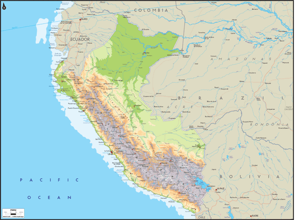
| Peru Wall Map from mapsales.com |
Though the Inca Trail may not
be a particularly long trek, measuring only about 20 miles, its grandeur comes
from its ancient status and its astonishing view. It was created centuries ago by the Inca of
Peru as a holy pilgrimage that prepared visitors to enter Machu Picchu .
Today, the government only
allows 500 people per day on the trail, and your spot has to be secured months
in advance. Hikers usually complete the
trek in about 4-5 days. Located in the Andes Mountains
near the Peruvian city of Cusco , the Inca Trail
gives hikers a unique view of Peru ’s
natural beauty. Views of white-tipped
mountains and high cloud forest combine with the magic of walking from one
cliff-hugging ruin to the next – understandably making this South America ’s most famous trail.
Though the trail may not be
one of the longest hikes, it is strenuous.
The Inca Trail takes hikers up and down winding paths, usually climbing
up a vertical mile from their starting point.
Dead Woman's Pass is the highest spot on the trail at 13,700 feet. After passing an ancient stone viewing
platform, which offers arguably the greatest view of the Andes in South
America, you reach the dazzling white stone city of Machu Picchu .
If you’ve made this
remarkable trek, or are planning to make it in the future, use a map to
commemorate the journey. Trace your
hiking path onto a wall map to see just how grand your accomplishment truly
is. Maps also make great mementos of
vacations and travel destinations.
Want to map a journey you’ve taken? Contact us! mapsales.com carries over 200,000 wall maps…including national park and road wall maps!
Click here for more maps of the world!
Subscribe to:
Posts (Atom)