Showing posts with label technology. Show all posts

Thursday, August 22, 2013

GbBIS at Oracle OpenWorld 2013

Join us at Oracle OpenWorld 2013!

Oracle OpenWorld in San Francisco 2013 features thousands of sessions from which attendees can choose, including keynotes, technical sessions, demos, and hands-on labs. Hundreds of exhibitors (including us!) will be on hand to share what they’re bringing to the leading edge of Oracle technology.

Look for GbBIS at booth 200!

GbBIS --Geography-based Business Information Solutions-- provides accurate postal data and mapping geographies, geo-data and analytics to manage growth and business operations. For a better understanding of customers, markets, optimal territories and site selection, GbBIS provides the geographic, demographic and location intelligence you need. 

And, you can still register below!


Thursday, February 21, 2013

Is GIS the Future? Prepare for New Jobs with Educational Wall Maps


GIS stands for Geographical Information Systems, systems designed to capture, manipulate, and present all types of geographical data. It combines technology, geography and data in ways that are quickly changing all aspects of life and how we approach the world. But are our children prepared to become the experts in this field? mapsales.com takes a look at the future job report, GIS innovations and educational wall maps to find out.

Recently in the news, we’ve heard reports about GIS being used to help fight crime in New York, Los Angeles and now Australia. The UN recently promoted the use of GIS in disaster risk reduction, preparedness and emergency response. All of these new innovations mean that GIS is an emerging sector of the workforce.

More jobs are a good thing, right? Not if Americans are ill-equipped to fill those positions.

In this letter to Congress, a former teacher urges everyone to support the Teaching Geography is Fundamental Act. He explains that “There is an enormous demand in both the public and private sectors for people with the ability to interpret and analyze geographic data. There are 70,000 new jobs in geospatial technology each year, but we are not training Americans to fill them.”

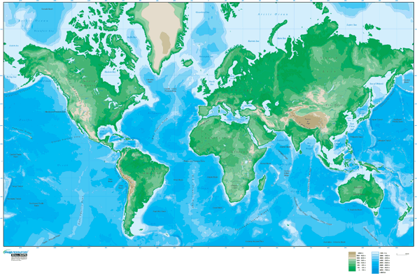
Educational Wall Maps - World
It is important to educate young Americans in the way that will best prepare them to take over governance of the USA. This includes immersing children with educational wall maps, and encouraging them to have an opportunity to become interested in the world. Most importantly, starting to do so at a young age. Think about encouraging geographical skills that could help the world and shop by grade level for Educational Wall Maps.

Do you agree that GIS will be the way of the future? How should we prepare our children for a technological world?

Tuesday, February 19, 2013

Alaska's Frontiers: Mapping Strategies for Mineral Resources


Alaska is known as the last US frontier, this Alaska Wall Map shows the vast land rich in minerals. The most difficult part is knowing what areas are important to mine and what areas shouldn't be mined. Here’s where mapping plays a key role. State geologists are mapping the potential of geographical areas from the land and air.

Why is Alaska so geologically important?

Part of that involves being located on the edge of the Pacific crustal plate. That also means multiple volcanoes and unpredictable weather. According to geological surveys, 40 million acres of state land possess high potential for mineral deposits. Only an eighth of this land has been mapped.

Alaska Wall Map

Top resources from Alaska include gold and oil, and they account for a large amount of Alaska’s wealth. Alaska also produces zinc, silver, copper, platinum as well as sand and gravel.

But state geologists are interested in rarer minerals. The strategy is to map areas with minerals strategic for military technology and/or that we import from other countries. This list includes: platinum group antimony, barite, chromite, cobalt, fluorite, gallium, graphite, indium, platinum group elements, rare earth elements, rhenium, tantalum, titanium, tungsten, yttrium and niobium. 

Producing these minerals would make the United States less reliant on importing them from other countries, saving money on technological advances. But mining takes a toll on any environmental system. By knowing exactly where the highest concentrations of minerals are located, environmental impact could be lessened.


Is it worth mining rare minerals and harming Alaska’s ecosystems for the economic independence?

Thursday, February 7, 2013

Digital Maps Versus Paper Maps


There’s a lot of media buzz recently about not only how amazing digital maps are, but also their failings. Do we rely too much on digital maps? mapsales.com takes a look at how technology has improved the usability of paper maps as well.

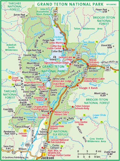
If you’re worried about bad weather affecting your paper maps while hiking or skiing, invest in synthetic paper maps. For example, while testing out Google’s Ski Resort coverage at Jackson Hole Mountain Resort, you can also take this Grand Teton National Park Map to check out the trails, museums, and other points of interest, without worrying about wear and tear or water stains.


Today we might still recognize the motif of a man refusing to ask for directions, poring over a large paper, fold-out map. That motif may well become obsolete. Our digital devices give a (mostly) precise description of our location and (mostly) correct directions to wherever we’d like to go, even speaking the directions so we don’t have to consult the on-screen map.

However, what happens when technology fails? Apple maps are the most well-known example of this failure, leaving a group in Australian stranded in a national park 40 miles away from their destination. Smaller mistakes do occur, as well as the very real possibility of running out of battery power.

The fact that, as Christine Ortiz notes in Why Digital Maps Aren’t Ready to Replace Paper, military personnel still prefer to consult paper maps, says a lot about the benefit of keeping a paper map backup in your car or backpack. This may be especially handy in areas where satellite coverage is sparse, with maps of the rural areas or National Park Wall Maps.

Check out more wall maps at mapsales.com.