Mali, an African nation once viewed as a democratic model, has been ravaged by conflict in recent weeks. mapsales.com takes a look the current conflict and the history of Mali.
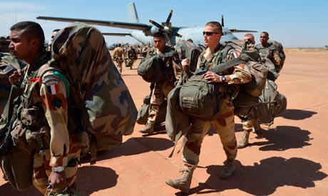
Last night, the French military launched its ground assault in the African nation of Mali. Their targets included the cities of Diabaly and Niono. Residents of Niono, a city in the center of Mali which is just south of a town that was overrun by Islamist extremists earlier this week, said they saw trucks of French soldiers arrive literally “overnight”.
Take a look at a Mali wall map to familiarize yourself with the region. Mali, a former French colony, has had a tumultuous past. After gaining its independence in 1960, Mali established a democratic constitution in 1991. It was a multi-party state until a conflict arose early last year. A group of soldiers seized the presidential palace, declaring the dissolution of the government and the suspension of the constitution. Rebels from the northern region of Azawad declared secession from the country in April 2012, but their declaration was withdrawn after being pressured by Islamist extremist groups.
A civilian government, led by interim president Dioncounda Traoré, was put in place by the junta. But Traoré was removed in a second military coup in December 2012. Since then, many regions of the country have become defenseless, with the national army unable to guard citizens from the violence of Islamist extremists in the northern desert. Earlier this month, the Islamists charged southward with a force of 800 to 900 fighters in 50 to 200 vehicles, taking over a frontier town that had been the de facto line of government control.
This was the act that drew France into the conflict. Worried that there was little to stop the militants from storming ever further into Mali, France sent its infantry into combat. But even with airstrikes around rebel camps and ground troops raiding rebel-controlled villages, the French have yet to remove the Islamist militants from the city of Diabaly, located only 250 miles from Mali’s capital.
Click here to view a zoom-able Mali wall map. Looking at the map of Mali, you can find the locations of major cities like Bamako, Niono, and Diabaly. The next time you see or hear a news story about an unfamiliar area, take a look at a wall map. Maps can help us learn more about what’s going on in the world.


No comments:
Post a Comment